Gallery · The Republic of Pirates · Room 1 of 6
The Harbour and Why It Worked
Curator's note
Every account of Nassau starts with the men. It is worth starting with the water instead, because the shape of the harbour explains almost everything that follows, including why the Crown had to offer mercy before it could use force.
"Harbour big enough to hold 500 Sail of Ships; before which lies a small Island, which makes two Inlets to the Harbour; at either Way there is a Bar, over which no Ship of 500 Tun can pass."
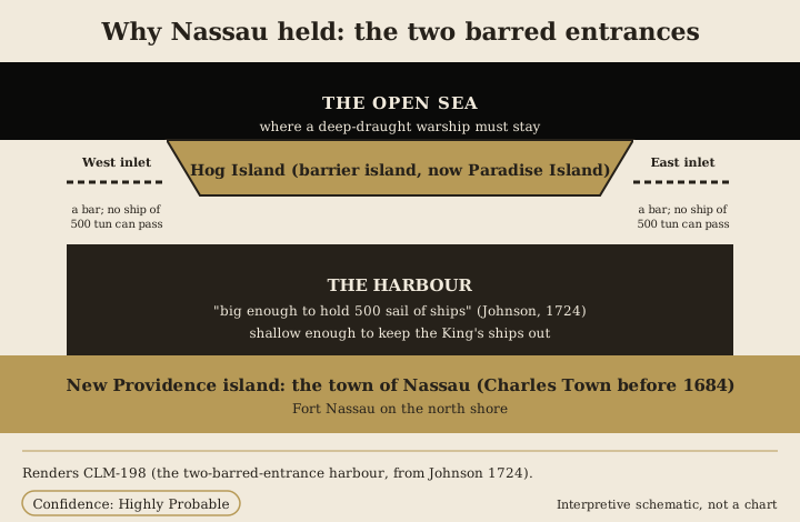
- New Providence island lies along the south, with the town and Fort Nassau on its north shore.
- Hog Island, now Paradise Island, lies across the harbour to the north.
- Between them the harbour is big enough, in Johnson's period sailing figure, to hold five hundred sail.
- At each end of Hog Island an inlet opens to the sea, and each inlet is crossed by a bar.
- A shallow fleet could use the harbour. A deep-draught King's ship was kept outside it.
- The drawing renders the period descriptions. Its entrance positions are derived.
The vessel the pirates favoured was the sloop: shallow, fast, weatherly and cheap to man. Nassau suited that vessel exactly. Its people could work the Florida Straits, where the homebound traffic of the Spanish and English Americas had to funnel through a narrow sea, and be back behind the bar within a day or two of a taking. A warship sent to end the business could lie outside the bar and watch.
The naming has to be exact, because the island and the town are two different things. The island is New Providence. The haven is the town on its north shore, called Charles Town until a Franco-Spanish raid destroyed it in 1684, and Nassau from its rebuilding in 1695, when it was renamed for William III of the House of Orange-Nassau.
Period charts of the place survive. Three of them are at The National Archives at Kew in the CO 700 Bahamas series: a Seller and Price chart and a Thornton chart, both catalogued at about 1700, and a draught of the fort and its outworks made under Governor Phenney in 1725 or 1726. They show the harbour, the bars and the fort much as the sailing description gives them. The fuller chart census belongs to the Nassau gallery.
By 1713 the War of the Spanish Succession was over, thousands of seamen were discharged, and the Bahamas had no functioning government to speak of. The proprietors held the islands on paper. What arrived to fill the gap is the subject of the next room.