Gallery · Place · PLC-002
Nassau / New Providence
Also recorded as: New Providence (the island); Charles Town / Charles Towne (the town, to 1684); Providence (period usage for the island)
New Providence island and its north-shore town of Nassau, the pirate haven of the 1710s and the colony Woodes Rogers reclaimed for the Crown in 1718.
The period charts of the island and its harbour survive at The National Archives, as CO 700/BAHAMAS 2, 3 and 4, and are not yet on display here. Until they are, Herman Moll's printed map of 1732 shows the island in its sea.
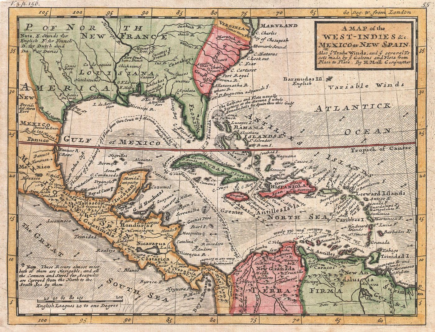
Two things have to be kept apart on every page that names this place. New Providence is the island. Nassau, called Charles Town before it, is the town on the island's north shore. The pirates held the town; the harbour in front of it is the reason they could.
New Providence is one of the Bahama Islands, lying at about 24 degrees north, east of Spanish Florida. Johnson's General History (1724) calls it the "most considerable of the Bahama Islands," about twenty-eight miles long. It is not Old Providence, Providencia, off the Central American coast; the "New" was added precisely to tell the two apart. The town sits on the north shore, and that town, not the island, is the pirate haven of this story.
The name sequence
The town has worn three names. It was Charles Town, or Charles Towne, from its founding in the 1660s, named for Charles II; the exact year is given variously as 1660, 1666 and 1670 across sources and is not settled. A Spanish raid destroyed it in 1684. When it was rebuilt in 1695 it was renamed Nassau, honouring William III, Prince of Orange and head of the House of Orange-Nassau, the rename attributed to Governor Nicholas Trott. The 1695 date and the Trott attribution rest on tertiary carriers and are graded Probable; the honoree and the rename itself are firmer. Period writers also call the island plainly "Providence," which is the island and not a fourth name for the town.
The harbour that made it work
Nassau harbour lies on the north side of the island, sheltered by a long barrier island then called Hog Island and now Paradise Island. That island splits the approach into two entrances, and a shallow bar crosses each. Johnson's period sailing description (1724) is exact: the harbour is "big enough to hold 500 Sail of Ships; before which lies a small Island, which makes two Inlets to the Harbour; at either Way there is a Bar, over which no Ship of 500 Tun can pass."
If you read that as a pirate would, the advantage is obvious. Shallow-draught sloops slipped in and out by either mouth, while the deep-draught men-of-war sent to suppress them could not cross the bar to close with the town, and one warship could not seal both entrances at once. The geography did the defending. It is why the place suited the trade, and why breaking it needed a governor with soldiers and small craft rather than a squadron.
The pirate era and the Flying Gang
The government of the Bahamas collapsed during the War of the Spanish Succession, when Franco-Spanish raids overran the town and the fort in the early 1700s and no legitimate resident governor was left. Into that vacuum came the pirates. From about 1713 to 1718 the town was theirs, perhaps a thousand of them at the height, the majority of the population, styling themselves the Flying Gang. Fort Nassau, built in 1697, stood in ruins.
The republic label
The phrase "Republic of Pirates" is modern. Colin Woodard's 2007 book of that name popularised it, and no pirate of New Providence ever called the place a republic. That said, it would be wrong to claim there was no period language for the idea. The period English word for a res publica was "commonwealth," and Johnson (1724) applies it to pirates repeatedly, writing of "the Name of a Commonwealth" and "the Commonwealth of Pyrates." He records the New Providence men, debating whether to accept the pardon, as being "for fortifying the Island, to stand upon their own Terms, and Treating with the Government upon the Foot of a Commonwealth." Johnson also calls the pirate town a "Colony of Rogues." So the fixed modern phrase is a coinage; the republican idea has a period cousin in "commonwealth," and the self-governing habits behind it, the sworn articles and the votes of the whole company, have their own records. The Archive uses "Republic of Pirates" only as a flagged modern label.
The retaking
The Lords Proprietors surrendered the civil and military government to the Crown in 1717. Woodes Rogers came as the first royal governor, arriving on 26 July 1718, the date fixed by his own despatch. About two hundred pirates took the King's pardon in the first days, a count graded Probable; his council ordered the fort repaired from August 1718. Charles Vane fled rather than surrender. Others took the certificate and went back to piracy, and the town's later story, the December 1718 trial, the 1720 Spanish assault repelled by an ex-pirate militia, and the 1720 proclamation that named John Rackham and his crew pirates, belongs to that reclaimed colony. Nassau is where the end of the Golden Age was administered.
Georeference
Nassau town centre sits at about 25.078 north, 77.339 west, on the island's north shore. The Old Fort Nassau site, on the north side of Marlborough Street, is now the grounds of the British Colonial Hotel, at about 25.078 north, 77.346 west, where wall remnants survive. Hog Island, now Paradise Island, which forms the harbour and its two entrances, lies at about 25.083 north, 77.333 west. The two harbour mouths are marked approximate, derived from Johnson's two-inlets description rather than from a survey.
The map spine
The period cartography sits in The National Archives series CO 700 (Bahamas), catalogued in full but mostly undigitised. Three items bracket the pirate era. CO 700/BAHAMAS2 is "Bahamas and Windward Passage," by Jeremiah Seller and Charles Price, London, about 1700. CO 700/BAHAMAS3 is "A new Chart of the Bahama Islands and the Windward Passage," by John Thornton, Hydrographer, about 1700. CO 700/BAHAMAS4 is the "Draught of the Outworks of the Fort Capt. Phenney has been building, 28th January 1725/1726," a manuscript plan of the Nassau fort just after the Rogers period, confirmed not digitised. They are catalogued and located; none is yet on display here.
What the sources cannot yet give is the paper trail for the town's own turning points: the founding year, the 1695 rename under Trott, and the wartime raids all rest on later carriers rather than on the calendared Colonial State Papers that would settle them.
Connections
- Woodes Rogers governed Nassau / New Providence
- The End of the Golden Age features Nassau / New Providence
Evidence behind this record
- Rogers arrived at Nassau on 26 July 1718, in his own words: "I arriv'd in this port 26th July in company with the men of warr ordered to assist me", naming HMS Rose and HMS Milford with his own ship the Delicia. The circulating 22 and 24 July dates are the fleet's approach, not his arrival in the port. State paper (own despatch): Rogers to the Council of Trade and Plantations, 31 October 1718, Calendar of State Papers Colonial vol 30 item 737 (manuscript CO 23/1)
- New Providence is the island; Nassau, called Charles Town before 1684, is the town on its north shore. The two must be kept distinct, and New Providence is not to be confused with Old Providence (Providencia) in the western Caribbean. Reference works and period narrative: Johnson, General History (1724); encyclopaedic and institutional carriers
- The town was Charles Town from its founding in the 1660s (year given variously as 1660, 1666 or 1670), named for Charles II; destroyed by a Spanish raid in 1684; rebuilt and renamed Nassau in 1695, honouring William III of Orange-Nassau, the rename attributed to Governor Nicholas Trott. Highly Probable Reference works: Britannica and other carriers; the exact 1695 date and Trott attribution rest on tertiary sources and are graded Probable, the rename and honoree Highly Probable
- Nassau harbour is sheltered by Hog Island (now Paradise Island), which makes two entrances each crossed by a shallow bar. Johnson (1724): the harbour is "big enough to hold 500 Sail of Ships; before which lies a small Island, which makes two Inlets to the Harbour; at either Way there is a Bar, over which no Ship of 500 Tun can pass." This double barred entrance is why the place suited shallow-draught pirate craft and defeated deep-draught warships. Period narrative (sailing description): Johnson, General History (1724), quoted verbatim
- After the collapse of Bahamian government in the War of the Spanish Succession, pirates occupied Nassau from about 1713 to 1718, perhaps a thousand at the height and the majority of the town's population, styling themselves the Flying Gang; Fort Nassau, built 1697, stood in ruins. Highly Probable Secondary carriers: Round estimate carried by secondary and tertiary sources
- "Republic of Pirates" is a modern coinage, popularised by Colin Woodard (2007), and no period source calls Nassau a republic. But period republican language exists: Johnson (1724) writes of "the Name of a Commonwealth" and "the Commonwealth of Pyrates", and records the New Providence men debating "Treating with the Government upon the Foot of a Commonwealth"; he also calls the pirate town a "Colony of Rogues". Highly Probable Period narrative and modern historiography: Colin Woodard, The Republic of Pirates (2007) for the fixed phrase; Johnson, General History (1724) for the period 'Commonwealth' language
- The Lords Proprietors surrendered the government of the Bahamas to the Crown in 1717; Woodes Rogers arrived as first royal governor on 26 July 1718, about two hundred pirates took the King's pardon in the first days (a count graded Probable), and his council ordered Fort Nassau repaired from August 1718. State paper and secondary carriers: Rogers's despatch (CSP Colonial vol 30 item 737) for the arrival; secondary carriers for the surrender and pardon numbers
- The period cartography of Nassau sits in The National Archives series CO 700 (Bahamas), catalogued in full but mostly undigitised. CO 700/BAHAMAS2 (Seller and Price, about 1700) and CO 700/BAHAMAS3 (Thornton, about 1700) bracket the pirate era, and CO 700/BAHAMAS4 is the manuscript 'Draught of the Outworks of the Fort Capt. Phenney has been building, 28th January 1725/1726', confirmed not digitised. Archive catalogue: TNA Discovery JSON API, CO 700/BAHAMAS2/3/4
- Woodes Rogers arrived at Nassau on 26 July 1718 as the first royal governor of the Bahamas, in company with HMS Rose and HMS Milford and his own ship Delicia, carrying the King's proclamation of pardon; his own despatch of 31 October 1718 states "I arriv'd in this port 26th July". Despatch: Rogers to the Council of Trade and Plantations, 31 October 1718 (Calendar of State Papers, Colonial, volume 30, item 737)
- Nassau harbour is sheltered by a barrier island (Hog Island, now Paradise Island) that creates two entrances, each crossed by a bar; the harbour could hold a large fleet but the bars kept out deep-draught warships. Johnson (1724) describes a "Harbour big enough to hold 500 Sail of Ships" before which "lies a small Island, which makes two Inlets", with a bar at either way over which "no Ship of 500 Tun can pass". This double-entrance, shallow-bar geography is what made Nassau a defensible pirate haven. Period sailing description: Charles Johnson, A General History of the Pyrates (London, 1724); corroborated by modern harbour geography
- The fixed phrase "Republic of Pirates" is a modern historiographical coinage popularised by Colin Woodard's 2007 book; it is not a period self-description. Republican and commonwealth language is nonetheless period-attested: Johnson (1724) applies "Commonwealth" to pirates and records the New Providence men debating "Treating with the Government upon the Foot of a Commonwealth". Period sources also called Nassau a "nest of pirates" and a "Colony of Rogues"; the pirates styled themselves the "Flying Gang". Highly Probable Historiography and period sources: Colin Woodard, The Republic of Pirates (2007) for the modern phrase; Charles Johnson, A General History of the Pyrates (1724) for the period "Commonwealth" language
- The place is New Providence, an island of the Bahamas; the pirate haven and later colonial capital is the town on its north shore, called Charles Town before 1684 and Nassau from 1695. The island and the town must be distinguished. Geographical record: Colonial and cartographic record of New Providence and its north-shore town
- Charles Town was destroyed by a Franco-Spanish raid in 1684 and rebuilt in 1695 under Governor Nicholas Trott, when it was renamed Nassau in honour of William III, of the House of Orange-Nassau. Highly Probable Colonial record: Colonial record of the rebuilding and renaming of the town on New Providence, 1695
- The principal period cartographic record of the place survives in The National Archives series CO 700 (Bahamas): CO 700/BAHAMAS 2 (Seller and Price, Bahamas and Windward Passage, about 1700), CO 700/BAHAMAS 3 (John Thornton, A new Chart of the Bahama Islands and the Windward Passage, about 1700), and CO 700/BAHAMAS 4 (a draught of the outworks of the fort Captain Phenney had been building, 28 January 1725/1726). These are not yet digitised. Highly Probable Cartographic record (undigitised): The National Archives, CO 700/BAHAMAS 2, 3 and 4
Open research
The island (New Providence) and the town (Charles Town to 1684, Nassau from 1695) are kept distinct on every page. The founding year of Charles Town (1660 / 1666 / 1670), the 1695 rename under Governor Nicholas Trott, and the early-1700s Franco-Spanish raid dates (Johnson's 1700 versus a tertiary 1703 versus the 'twice during the war' of the 1705/06 Lords address) all rest on later carriers and need the Colonial State Papers, which are not yet in evidence here. Harbour-entrance coordinates are derived from Johnson's two-inlets description, not a survey. The CO 700 (Bahamas) charts are catalogued but mostly undigitised.